Wednesday, July 15, 2026

Aerial Tree Seeding in 2026: Ten Years On

An AI-assisted review of where aerial tree seeding has taken us since our first trials in 2016.

When we started this blog back in 2016, aerial tree seeding in East Africa was still very much an experiment.

Our aim was simply to collect ideas, research papers, videos and experiences from around the world and see whether any of them could be adapted to tropical Africa. At the time, there was surprisingly little published work on aerial seeding in dryland tropical ecosystems, particularly using indigenous tree species. (Seedballs Kenya)

We were asking questions rather than claiming to have answers.

Could seed coatings improve survival?

Would biochar seedballs reduce seed predation?

Could helicopters, fixed-wing aircraft or even balloons become practical restoration tools?

Which species might actually work?

How much of the challenge was engineering, and how much was simply ecology?

Ten years later, many of those questions remain. But we have learned a great deal.


One thing hasn't changed...

Nature is still in charge.

Aerial seeding is simply another way of dispersing seed.

Once that seed reaches the ground, exactly the same ecological processes take over as they have done for millions of years.

Rainfall.

Competition.

Soils.

Microsites.

Browsing.

Fire.

Seed predators.

Luck 🍀

Some of the ideas from 2016 still seem remarkably relevant

Looking back at our original list of research priorities, many remain active areas of research today. 

These included:

  • matching the right species to the right sites

  • improving seed coatings

  • protecting seeds from rodents, ants and birds

  • developing coatings that retain moisture

  • improving aerial delivery systems

  • determining the best methods of seed broadcasting

  • understanding seasonal grazing pressure etc.

Interestingly, these are still among the biggest questions being asked by restoration scientists today.


What has changed?

Probably the biggest difference is not the seed.

It's the information.

In 2016, most aerial seeding simply involved dropping seed over suitable-looking habitat.

Today we have access to tools that barely existed ten years ago.

Digital communication to communities in restoration areas

Satellite imagery.

High-resolution drone mapping.

LiDAR.

Artificial intelligence.

Machine learning.

All of these can help decide where seed should be placed rather than simply how it should be distributed.


How AI is beginning to help

Artificial intelligence will not replace foresters, pilots or ecologists any time soon.

Instead, it is becoming another tool that helps us make better decisions.

Around the world, researchers and restoration companies are beginning to use AI to:

  • identify degraded areas from satellite imagery

  • distinguish grassland from regenerating woodland

  • map erosion and water flow

  • identify suitable microsites for different tree species

  • optimise drone flight paths

  • estimate vegetation recovery from repeated aerial surveys

  • automatically count seedlings from drone photographs

  • predict which restoration sites are most likely to succeed based on rainfall, soils and previous monitoring. (ResearchGate)

The right seed.

In the right place.


Trees and UAVs

When we began this blog, drones capable of carrying useful payloads were still relatively uncommon.

Today they are becoming standard restoration tools.

Unlike aircraft, drones can:

  • fly low and slowly

  • revisit exactly the same location

  • map restoration sites before seeding

  • monitor germination afterwards

  • reach steep or inaccessible terrain

  • distribute seed in small targeted patches rather than entire landscapes.


With Kenya Flying Labs and Konza Technopolis

KBC Business News https://www.youtube.com/watch?v=CiBr_n5DG40 


Kenya has also moved forward

One exciting development is that aerial seeding is no longer just an interesting experiment.

It is becoming part of national restoration planning.

Recent pilot projects in Kenya have demonstrated that aerial seeding can restore difficult terrain at a fraction of the cost of conventional seedling planting while covering thousands of hectares in only a few days. The pilots have also highlighted important lessons, such as matching species to sites, involving local communities, and recognising that very light seeds may require pelleting or seedballs to improve targeting. (Drone seeding)

It is encouraging to see many of the questions we were asking in 2016 now being tested at operational scales.


But let's not get carried away...

There is also a tendency for aerial seeding to be presented as a miracle solution.

It isn't.

All projects around the world will always face:

  • germination

  • climatic change effects

  • seed and seedling attrition 

  • lack of long-term (multi decadal) monitoring.


Biochar Seedballs 

One of the reasons we became interested in seedballs in the first place was that they addressed several of the practical problems associated with aerial seeding.

They can:

  • increase seed weight and size for more accurate aerial distribution

  • protect seeds from some predators

  • reduce mechanical damage during broadcasting

  • incorporate nutrients or beneficial microbes

  • potentially retain moisture around germinating seed

  • allow mixtures of different sized seed species to be distributed together.

Whether these advantages justify manufacturing costs depends on the ecosystem, timing, species and restoration objectives.


A final thought

Back in 2016 we ended our first article by saying:

"After all, hundreds of species of trees have spent millions of years perfecting aerial tree seeding. With a bit of help, perhaps with technology and information transfer, we can find a way to make planting and growing billions of trees more cost effective."

Ten years later, that still feels true.

Demand for wood products is ever increasing 

Technology keeps improving.

Aircraft are becoming smarter.

Drones are becoming more capable.

Artificial intelligence is helping us understand landscapes in extraordinary detail.

But forests still grow one seed at a time.


Editor's note

This article was AI-assisted. Artificial intelligence was used to help review recent literature, identify emerging technologies, organise information and draft most of this text. The opinions, field observations and editorial direction remain those of Seedballs Kenya, and—as always—we welcome corrections, new research and practical experiences from others working in aerial restoration.


Friday, August 6, 2021

Seedballs vs. Seed eaters

Finally! A video that's taken a long time to get 🙂 Here's a very cute and relaxed little grass rat (unstriped Nile grass rat, Arvicanthis niloticus) near Shompole chowing down on some grass seeds and not even paying the slightest attention to the grass seedballs right next to it 😃


Some vervet monkeys rejecting some acacia tree seedballs as 'not fit to eat' near Lake Elementaita.

Tuesday, April 7, 2020

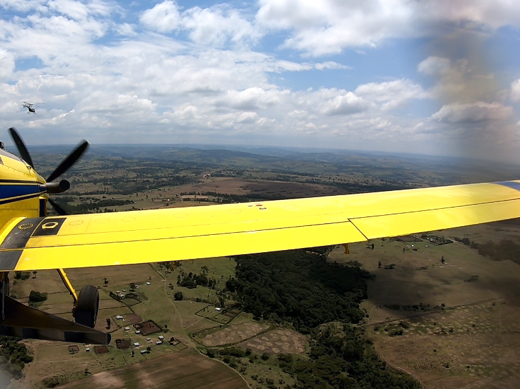
Piggybacking tree seed distribution onto aerial patrols.


Illegal charcoal making and its after effects pose a huge challenge to the biodiversity health of dryland areas all over Kenya. Old growth (generally acacia) trees are cut for their high quality wood that is made into charcoal for the cooking needs of Kenya's rapidly growing urban populations. Sadly this not only removes key tree species from landscapes, it also burns the land where the charcoal was made and depletes natural seedbanks.(https://kenyacharcoal.blogspot.com/2019/12/rehabilitation-of-traditional-charcoal.html)

But thanks to our amazing ReGreen Kenya partners like the Mara Elephant Project, who can piggyback seedball distribution into their day to day patrol work, we can at least help to get the right species of indigenous tree and grass seeds into the right degraded areas to help start reversing some of this long term damage right away.


Prior understanding of eco-system and selective logging types to match species per location is key.


Calculations for how many seeds (or seedballs) can be distributed should be planned well in advance by the Pilot and collecting GPS points on distribution locations for future follow ups is highly advised.


If you would like to help and send them or any of our other partners a big bag of seedballs to plant on your behalf in areas like these - please see here; http://www.seedballskenya.com/donate/4594311653


Sunday, October 6, 2019

Spreader Setup for Aerial Application

Spreaders are attached to agricultural aircraft and used to distribute seeds, fertilizers and dry chemical products. The first time an airplane was used to treat crops was in 1921 when a U.S. Army pilot applied insecticide to Ohio’s catalpa trees infested with moth. Since then, agricultural aviation has proven to be a fast and efficient form of product application to our crops.


The most common spreader used in agricultural aviation in the United States is the venturi or RAM spreader. Venturi spreaders clamp to the gate box at the base of the aircraft’s hopper. The gate boxes are 25, 38 or 41 inches wide depending on the size of the aircraft. As the adjustable door (gate) on the gate box opens, material from the hopper falls into the venturi spreader, and it is distributed by the airflow through the spreader. The opening of the door determines the flow rate. Some of the limitations on venturi spreaders include high aerodynamic drag, high power requirements and low quality pattern of distribution for high application rates (greater than 250 pounds per acre).


The venturi spreader is composed of ducts, also called vanes that can vary in number from five to 13. Each vane has adjustable sections at the front or rear. Adjustments on the front portion of the vane modifies the amount of material and air that moves through it. Adjustments of the rear section of the vanes may change the initial path of the material leaving the spreader.


 As an aerial applicator your job is to deliver product (fertilizer, seeds, etc.) on time, with great quality and precision. Major concerns to applicators are swath width, uniformity and operation efficiency. How the spreader is mounted (attitude), the rate of application and variations in the material’s physical properties have major effects on swath width and uniformity of application. Larger swath widths will increase operation efficiency (acres per hour), a “must-do” today with the increasing operational costs.


Variable-rate application (VRA) is a technique often used by progressive farmers in which different product rates are applied in the field in an attempt to match varying field requirements according to features such as soil type or field topography. Farmers and agricultural consultants work together to develop variable-rate maps. Computerized systems for variable-rate application of dry material are available for agricultural airplanes.


These systems automatically adjust gate opening during flight, releasing more or less material according to a prescription map, ground coordinates and aircraft speed. The system also can be used to adjust material release based on aircraft ground speed, offering a precise single-rate application. VRA may be a great option for farmers wishing to apply precision-farming technology to their fields, and it may offer aerial applicators the opportunity to add value to their services, therefore enhancing their level of customer service.


With credit to https://aerialspray.co.za/ewExternalFiles/pub3078SpreaderSetupforAerialLOWRES.pdf  and Farmland Aviation Kenya.

Sunday, July 21, 2019

Drones, Data and Forestry

The linkages between UAV's (Unmanned Aerial Vehicles), forestry and eco-system management have only just begun to mature. There is extensive potential for these tools to fill in gaps in current practices while providing thousands of 'green coller' digital jobs in the environmental service industry in East Africa.

Below are some links and information about drones for forest landscape management, mapping and restoration.


1. Forest mapping and biodiversity

Drones of various shapes, sizes, and functionalities have emerged over the past few decades, and their civilian applications are becoming increasingly appealing. Flexible, low-cost, and high-resolution remote sensing systems that use drones as platforms are important for filling data gaps and supplementing the capabilities of crewed/manned aircraft and satellite remote sensing systems. Here, we refer to this growing remote sensing initiative as drone remote sensing and explain its unique advantages in forestry research and practices. Furthermore, we summarize the various approaches of drone remote sensing to surveying forests, mapping canopy gaps, measuring forest canopy height, tracking forest wildfires, and supporting intensive forest management. The benefits of drone remote sensing include low material and operational costs, flexible control of spatial and temporal resolution, high-intensity data collection, and the absence of risk to crews. The current forestry applications of drone remote sensing are still at an experimental stage, but they are expected to expand rapidly. To better guide the development of drone remote sensing for sustainable forestry, it is important to systematically and continuously conduct comparative studies to determine the appropriate drone remote sensing technologies for various forest conditions and/or forestry applications. Link to paper> © 2015, Northeast Forestry University and Springer-Verlag Berlin Heidelberg.

2. Precision forestry and forestry management

Different parameters relating to forests such as the extent of canopy cover, the number and species composition of trees and volume estimation can also be achieved efficiently through the use of unmanned aircrafts. This data collected by use of drones are usually accurate and can help in quick and better decision making as opposed to other methods.

3. Mapping canopy gaps

Forest disturbances are mostly caused by storms or human interference and these have a direct impact on the productivity of forest stands. This also affects regeneration. Satellite imagery was initially used to access this kind of data by mapping the canopy gaps but the information was not as accurate as it needed to be. This however changed with the introduction of drone remote sensing.

4. Measuring forest canopy gaps and other important attributes

Canopy heights and other canopy attributes are some of the best features of forest used by forest professionals. This data needs to be accessed accurately and thanks to LiDAR technology that can now be mounted on drones, the information can be accessed fast and efficiently.


5. Capturing forest data

Drones can now be used to capture vital forest data such as planting success rates, vegetation change and health, canopy attributes such as canopy gaps, canopy heights and even the extent of carbon storage within a forest. This information is not only relevant to forest researchers but also to forest farmers.


6. 3D mapping for carbon storage

In the past, measuring the extent of carbon storage in biomass has been very labor intensive and very expensive. But thanks to the introduction of drone technology, remote sensing can now be used to get 3D mapping of carbon storage within forests of many types.

7. Restoration of scorched land and firefighting support

Wild fires often cause extensive damage to land and soil after the fire has been extinguished. The process of land restoration is what takes years as it requires extensive land survey and tree planting that could take years. Drones can be used to do these surveys fast and reduce the cost and time of land restoration and aerial seeding.


Drones can even be used in firefighting. Using a built in camera, a firetower is able to detect the thermal signature of forest fires that are beginning within a 15-km (9-mile) radius of itself.

When a fire is detected, the tower's computer determines the geographical location of the blaze, and then "awakens" the drone by sending it an email with those coordinates – that same email is also sent to a fire-fighting crew at a base station. The GPS-guided drone proceeds to autonomously fly out to the fire, using its own thermal and optical cameras to obtain and transmit visuals back to the firefighters.
https://newatlas.com/forest-fire-drone/60213/

https://uavcoach.com/drones-fire-departments/

Take, for example the FVR-90, a fixed-wing drone with a 14-foot wingspan capable of traveling at speeds up to 80 knots, or 46 mph, with a flight time of 8 hours. They are sent airborne just at dusk when other human-piloted flights are grounded. The sky is theirs, and the overhead view they have of the fire is detailed and in real time.

“The way we use UAS now is very much a supplement,” said Justin Baxter, the Forest Service National UAS Operations Specialist. “There are certain times that it’s just not safe for us to utilize manned helicopters or fixed-wing aircraft, like nighttime operations or in thick smoke or high winds. But during those times there are still firefighters out there trying to complete the day's objectives and put the fire out.”

The drones that Baxter and his team fly are equipped with cameras that are not your normal cameras. They come equipped with multiple types of sensors, including infrared, that allow the team to see through smoke and, at night, see heat signatures, or thermal-based imaging. This allows the team to identify areas where fire is still active and new areas where flames have advanced, such as spot fires. https://www.fs.usda.gov/features/mechanized-birds-wildland-firefighting-drone-intelligence 


8. Tree planting with drones 🌱🌱

Planting trees in remote areas hard to reach is not an easy task. The land is often not evenly distributed and it is sometimes inaccessible. Drones can be used to distribute seeds and seedballs in these areas in a fast and efficient manner and ensure adequate seed distribution rates. (Longer detailed blog on aerial seed application in East Africa here (https://seedballskenya.blogspot.com/2016/08/application-of-plant-seed-using-aircraft.html


Drone seeding in Somalia with UNSOM and Seedballs Kenya https://unsos.unmissions.org/reforesting-somalia 


The first KCAA licensed drone seed dropping demo in Kenya by KENDRONE in Mombasa https://www.facebook.com/KendroneKenya/videos/182002460455388 


Some companies are even looking into using drones for tree seed collection:


9. Forest surveillance

Drones are now being used to do aerial surveys of rainforests to determine where the trees have been affected by human activities and the patterns being used to achieve this. Drones can then relay the data to the relevant authorities who use it to make informed decisions.


10. Monitoring illegal quarrying

Drones can be used to monitor illegal quarrying especially in forested areas that cannot be easily accessible by humans. Drones can fly over these areas and take clear shots of the damage that has been caused in these areas and advise authorities on corrective measures to take.

12. For dropping fertilizer or spraying herbicides

One of the toughest and labor intensive jobs is the sprinkling of fertilizer/herbicides in forested areas. Drones have come in handy in helping to spread fertilizer etc. over forested areas that were previously inaccessible. And also reduce exposure to human operators for dangers herbicides.


15. Forest security

A lot of forest cover is being lost to unscrupulous business people through logging and this ends up causing global warming. Law enforcement authorities have also employed the use of drones to do forest cover monitoring to arrest the people who are destroying them.                      


The following is a list of some recent research and news articles as well as links to just a few of the various companies offering Forestry/UAV related services in Kenya:

https://www.expertdrones.com/eastafrica